Data and discipline - ViaNova puts Trimble Quadri central data environment at the heart of highway project
Customer profile: ViaNova is a multi-disciplinary civil engineering consulting company based in Norway, that plans and designs new roads - from early investigation and feasibility analysis to construction planning, construction progress monitoring, management, operation, maintenance and rehabilitation. They manage the building information management (BIM) coordination on major civil projects across the country, with a focus on information sharing across the project collaborators. ViaNova is the essence of collaboration, consisting of independent specialized firms with diverse disciplines, working together on civil engineering projects. Tone R. Kristiansen and Andreas Haugbotn are experienced 3D BIM coordinators who have seen their roles develop from 3D modeling to orchestrating information flows across complex, multi-stakeholder projects.
Business challenge: The requirements for this design and build project determine that each discipline has to work in a model-based format, with predefined detailed criteria. This way of working requires a multidisciplinary quality check, including collision detection, before delivery to site.
Solutions:
- Trimble Quadri Software
- Trimble Novapoint Software
- Trimble Connect a cloud-based common data environment (CDE)
- Trimble Access Field Software
On the E6 motorway project for the Norwegian Public Roads Administration, ViaNova works with general contractor Leonard Nilsen & Sons and subcontractors Risa and HAK on a project comprising 10km (6.2 miles) of new road between the towns of Svenningelv and Lien, including the relocation of railway tracks, the construction of 2 large bridges and one tunnel.
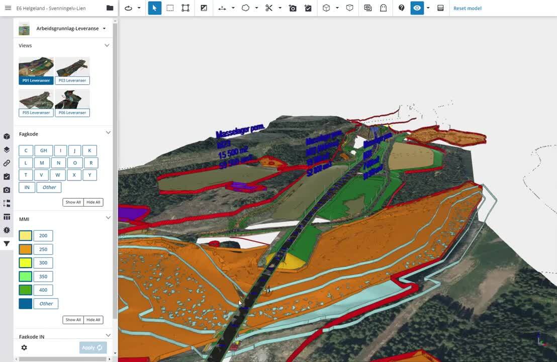
Central in the ViaNova approach is a common data environment based on Trimble Quadri. It forms the “data heart” of the project, connecting design data, surveyed data and information from various sources.
“It’s all about the process,” says ViaNova’s Andreas Haugbotn. “Central to success on this project is an understanding and enablement of the information needs, using the full potential of Industry Foundation Classes (IFC) open standards.”
Trimble Quadri serves as the common data environment, with project information shared amongst multiple stakeholder groups, each pulling information from and adding information to the shared model from their respective disciplines. On the side of the owner and general contractor information from Microsoft Office applications is shared through a Microsoft SharePoint-based project portal. It provides access to BIM documents and manuals, training and resources information. It is also the place for these teams to get model data based on both the design and GIS data captured from the site, and it provides the basis for construction and handover description. Along with the SharePoint portal, the team uses a Miro collaboration management dashboard. Management issues are channeled through Jira tickets and risk management issues are worked through on a custom application.
Trimble Connect
On the project, Trimble Connect serves as the main cloud access solution, with all devices on the job using the browser interface so that everyone involved on the project works with the same interface and has access to the appropriate functionality, across the project. “Trimble Connect provides us with access control for assessment of IFC in progress in the design phase and to publish quality assurance IFC in the construction phase,” says Andreas. “It has a powerful viewer so all stakeholders can get a detailed online view of the model with up-to-date information that is important for their role.”
Quadri Connectors
On the design side, Quadri connectors play a crucial role in making sure data can be shared from multiple data sources. Information is accessed through Trimble Connect and exchanged with local server IFC models. The connectors make it possible for Quadri to operate as a BIM server on the project, hosting information from a plethora of applications: Trimble Novapoint as the design toolset for infrastructure (road, rail, markings and signage), third party software for landscape design and construction data, Tekla for construction and tunnel design data, Grasshopper for electrical design data, base-data and as-built information. The Tekla Structures connector allows Trimble’s structural engineering software to provide automated labeling and to share rebar and foundation work in the federated model.
The model is shared with the general public in a presentation format based on exactly the same model that the designers, contractors and other stakeholders are working from. In the field, progress can be tracked against the model through the use of augmented and virtual reality solutions such as Trimble SiteVision.
Properties
“When all the building blocks of the BIM strategy process are in place, it comes down to execution discipline,” says Tone Kristiansen of ViaNova. “Based on information requirements, we determine the data delivery structure and formats, the workflow, level of detail, and the processes that all stakeholders need to commit to.”
“Information structuring is a real key to success,” Tone continues. “It saves time to discuss and decide on the right structure of properties, as properties convey information that is required for construction without paper drawings at the beginning of a project.” Andreas: “On this project, we can filter and search based on multiple variables such as discipline, level-of-detail and text labels, and because we have taken the time to pre-define properties, the take-off information for subcontractors and suppliers is easy. You just need to write import rules to get information into the various solutions like Novapoint. And with that, the information flows through Quadri, and you can export it out GML, IFC or DWG format, just as you like. This makes Quadri the ideal center of any common data environment.”
Drawingless construction
“We try to do all of the structural construction work entirely without drawings,” Tone states. “In the beginning, the contractor created drawings from the IFC files using Tekla Structures, but after a period of familiarization with the Trimble Connect tool, they now work with 2D drawings directly based on the information from Trimble Connect.
The rebar supplier gets an order through the system and they can also ‘tag’ an object in the model with, for example, information on delivery times. This interactivity enables everyone to work with up-to-date, enriched data.
Stake-out
“On the E6 project all stake-out data goes into the model,” says Andreas Haugbotn. A surveyor uses Trimble Access to capture the as-built 3D data - lines and points - and the new geometry (with property data) is compared against the old, with volumes getting generated automatically. The new geometry can then be viewed in Trimble Connect. Trimble Access is the best tool to pick the line and stake out the data without any distortion.”
Also adding to the complete overview of the as-built geometry is the reporting coming from the compactor equipped with Trimble Compaction Control Systems. Working with the same properties set, the report provides progress information on the number of passes, which can be visualized in Trimble Connect.
Sustainability
The Norwegian Road authority has an environmental specialist that follows the activity on this project closely because the new road is being constructed close to environmentally protected areas. Therefore the machines are geofenced, based on the area model. This georeferencing will ensure that machine operators steer clear of the protected wildlife breeding areas. Occasionally, digging can result in too steep inclines with a risk of falling rock disturbing the area, and this is when the specialist steps in to order extra measures to be taken.
The carbon footprint of the active project is monitored constantly by automatic reporting through Grasshopper software on the CO2 emissions based on information stored in the IFC files and data coming from sources like the bill-of-materials and GIS data on soil types (e.g. the location of marsh areas) to take into account emissions from soil disturbance.
The Outcome
“A CDE approach saves time and prevents loss of information,“ says Andreas. “Most importantly, thanks to the CDE, everyone works from a single source of the truth, which dramatically reduces the risk of mistakes.”